

Historical inequities create modern “heat islands”
by Sydney Cromwell
On sweltering summer days in Birmingham, the heat seems to shimmer above roads and sidewalks.
It’s more than a trick of the eye. Temperatures are consistently higher in areas where heat is reflected by buildings, asphalt and concrete rather than absorbed by trees and green spaces, an effect known as an “urban heat island.”
Heat islands are common in cities’ commercial and heavily developed areas. However, research in Birmingham and across the country is also showing a connection between the heat islands of today and neighborhoods affected by racist “redlining” policies of the past.
DEGREES OF SEPARATION
It’s simple to predict what parts of Birmingham will be the hottest: look for where the trees are not.
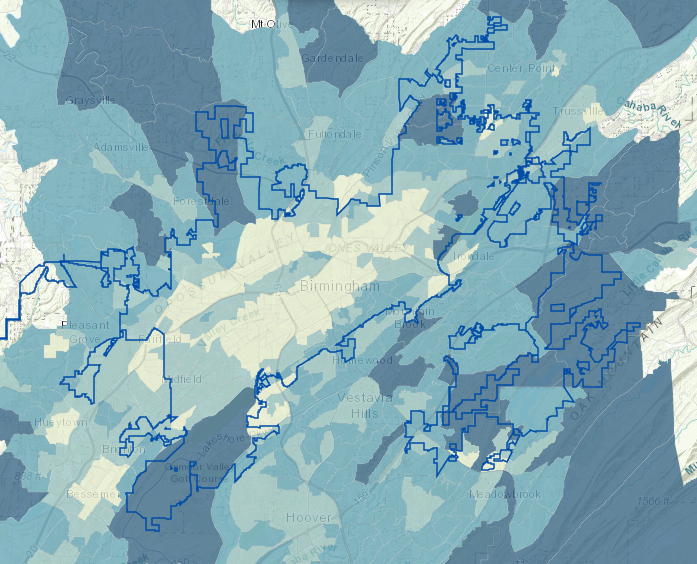
Francesca Gross, an environmental specialist with the Cawaco Resource, Conservation & Development Council, spent two years studying the relationship between Birmingham’s tree canopy, temperatures, stormwater flooding and air quality with the help of UAB’s Lister Hill Center for Health Policy and the Nature Conservancy’s Alabama chapter.
The results of the project, called Cool Green, make the value of trees, parks and green space of every kind quite clear, Gross said.
“The tree canopy is critical. … Trees are just an easy, natural solution,” Gross said.
Cool Green studied EPA EnviroAtlas data for Jefferson and Shelby counties. Unsurprisingly, the data showed that downtown Birmingham has far less tree coverage and far more impervious surfaces (such as buildings, roads and parking lots) than the suburban and rural parts of the city’s metro area.

The neighborhoods with the fewest trees tend to have the least change in temperature during summer nights, Cool Green found, which means that daytime heat is being trapped rather than dissipating away. Where the heat can’t escape, a heat island can form and cause several degrees of temperature difference compared to more shaded neighborhoods.
Sometimes the difference can be stark; Mountain Brook and Lakeview, for instance, are only a few miles apart, but Mountain Brook has more tree coverage and cools off by 3.5–4.4 degrees at night, while the more developed Lakeview averages less than 1.5 degrees of nighttime temperature reduction.
The pattern starts to look familiar as you study the maps that Cool Green produced: where there are more trees and parks, there is less stormwater runoff, less air pollution and less heat.
In Birmingham’s densely developed commercial districts, this pronounced heat island effect is expected because parks and green spaces are scarce. But in residential areas, the amount of green space — and, consequently, the amount of excess heat — has been partly determined by decades-old decisions on which neighborhoods were most worthy of investment.
REDLINING’S GENERATIONAL HARM
Neighborhoods that were “redlined” in the first half of the twentieth century were deemed less valuable or as “hazardous” investments by banks, lenders and even local government, often on the basis of racial makeup or poverty levels.
Many banks used Home Owners’ Loan Corporation (HOLC) maps with literal red lines drawn around undesirable areas, green lines around wealthier, whiter neighborhoods and blue or yellow lines around areas considered “Still Desirable” or “Declining,” respectively.
Within those red lines, loan applications were more likely to be denied or to be given higher, sometimes predatory interest rates. These practices made it harder for poor and minority families to buy homes, pay off mortgages and afford upkeep and improvements to those properties.

Redlined neighborhoods have also had a harder time attracting retailers and in some cases have been targeted for construction of highways and heavy industry rather than community-building amenities like parks and sidewalks.
Yohance Owens, the executive director of the Village Creek Human and Environmental Justice Society, said his organization is often called upon by neighborhood association presidents for help on a number of environmental issues. Sometimes that has included opposition to the construction of businesses like landfills or cement companies near residential communities.
“Yes, those are bringing jobs, but also they’re bringing health problems,” Owens said, due to the air, water and soil pollution they can cause.
Discriminatory lending practices were outlawed with the Fair Housing Act of 1968, although some banking and lending institutions have been caught continuing the same policies in all but name.
The 53 years since the Fair Housing Act have not erased the effects of redlining and lack of investment. Formerly redlined neighborhoods tend to have higher rates of rental versus home ownership, more abandoned and foreclosed properties and lower property values than green-lined neighborhoods a couple miles away.
“If you put a map of the redlining in Birmingham with a map of the tree canopy, … it matches up almost exactly.”
Francesca Gross, Cawaco Resource, Conservation & Development Council
And since home ownership is one of the most common ways for families to pass wealth down to children and grandchildren, the barriers to investment that redlining created affect multiple generations, even after those discriminatory practices are no longer in place.
The neighborhoods of Birmingham that were redlined from the 1930s to the 1960s still show the remnants of those policies. A 2018 map of Jefferson County created by the Health Action Partnership’s Community Health Equity Report showed that the highest poverty levels in the county are still clustered in many of the same Birmingham neighborhoods that were redlined as bad investments.

Through the Cool Green project, Gross said she found that these poorer urban neighborhoods of Birmingham generally had less tree canopy and more heat than wealthier neighborhoods.
“If you put a map of the redlining in Birmingham with a map of the tree canopy, … it matches up almost exactly,” Gross said.
That tree canopy can come in the form of public parks, business landscaping and backyard trees — anything that breaks up the landscape of impervious surfaces.
National studies have shown a consistent link between urban heat islands and redlining. A 2020 study of 37 cities found that formerly redlined neighborhoods had, on average, about half as much tree coverage as the neighborhoods considered most desirable (green-lined) by the HOLC.
Various researchers in 2021, 2020, 2013 and 2006 have also shown that poorer urban areas are more likely to experience heat island effects.
“When folks weren’t allowed to invest in real estate, it changed the whole dynamic in everything from clean water, stormwater, trees,” Gross said.
HEAT HAZARDS
Urban heat islands are more than just a source of summer discomfort; they can also be dangerous.
The U.S. Environmental Protection Agency (EPA) recorded an average of 700 heat-related deaths per year between 2004 and 2018, making extreme heat deadlier than flooding, hurricanes and other weather events.
Along with heat stroke and heat exhaustion, warmer temperatures can make existing health conditions, particularly cardiovascular and respiratory illnesses, more severe. People with chronic health conditions, young children, senior citizens and outdoor workers are at the highest risk.
Rates of chronic illness are often higher in neighborhoods where health care is inaccessible and unaffordable. The 2018 Community Health Equity Report showed that in Jefferson County, communities with higher poverty rates frequently also had higher rates of disability and lower life expectancy.
Cool Green also found that areas with fewer trees had higher levels of air pollution, another health risk that is more likely to affect lower-income communities.
Gasp Birmingham, which tracks levels of air pollution at a number of sites around the city, says on its website that neighborhoods like North Birmingham, Collegeville, Fairmont and Harriman Park live with higher air pollution due to the heavy industry that surrounds them.
“Those who suffer the most from dirty air tend to have the least amount of power to create and affect change,” says a Gasp article on environmental justice.
According to the 2018 National Climate Assessment, one of the primary ways climate change will be felt in Southeastern cities is through the health impacts of more frequent and more intense heat waves.
Without changes in urban planning and heat management, the human costs of urban heat islands are only expected to become more severe.
A FLOOD OF PROBLEMS
Heat islands can often exist alongside stormwater flooding issues, stemming from the same source. The impervious surfaces that are reflecting heat are also preventing water from being absorbed.
During heavy rains, the stormwater in developed, mostly urban areas must flow down streets and sidewalks until it is collected by Birmingham’s sewer system. But the city’s stormwater sewers were built long before Birmingham reached its current size and population, creating capacity problems.
“Most of the stormwater system in downtown is sort of ancient,” Birmingham senior planner Donald Wilborn said. Some of the sewer lines were installed more than 100 years ago.
During heavy storms, temporary flooding can happen as water backs up in inadequate stormwater sewer lines. Some of that water also flows directly into Birmingham’s creeks, carrying with it polluting materials picked up on the water’s journey across asphalt, brick and cement.
“We’re not alone in that, especially being an old industrial city,” Gross said. She compared Birmingham to cities like Detroit and Washington, D.C., with similar infrastructure problems.
The size of stormwater sewer lines also affects Birmingham’s neighboring cities like Bessemer, Hoover, Pelham and Vestavia Hills, though mainly in highly developed commercial areas, according to Cool Green mapping. Homewood has a significant tree canopy, but residents are still seeing problems with stormwater flooding due to infill development, covering lots with larger homes, driveways and other impervious surfaces.
Owens said he sees flooding happen regularly around Birmingham’s stormwater sewers and creeks. When he was in high school, Owens said some families would have to temporarily leave their homes due to the flooding.
This was part of the inspiration for the Village Creek Society’s creation in the 1980s. The society has focused on flood control and stabilizing the banks of Village Creek, along with cleanups and encouraging enjoyment of the creek by its neighbors.
“We’re called upon any time there’s flooding,” said Owens, who joined the society in 2014.
Flooding issues in Village Creek are better controlled now due to work by the society, the city of Birmingham and the Jefferson County Stormwater Management Authority (SWMA), Owens said. He added that SWMA does a lot of unsung work in regulating runoff from construction and business sites, managing watersheds and monitoring pH levels in the county’s waterways.
However, fixing or replacing sewer lines on a large scale is an expensive proposition. Jefferson County declared bankruptcy in 2011 with over $4 billion in debt related to sewer repair projects, after the 2008 financial crisis.
Wilborn said most Birmingham sewer improvement projects are done in tandem with construction or redevelopment on individual properties, or where age and damage is “so critical that we’ve had no choice but to replace that system.”
Gross said use of “green infrastructure” can be a cheaper and faster solution for flood control, as trees and landscaped bioswales can trap, absorb and filter runoff before it ever reaches a stormwater sewer line or creek.
In East Thomas and Ensley, Owens said the Village Creek Society is working on plans to use trees and other plants as a natural form of creek flooding control.
Wilborn said the city has been working with the SWMA about ways to promote use of green infrastructure and permeable construction materials, which can absorb more water than traditional materials. He said the city has also been working with the U.S. Army Corps of Engineers on ways to improve the conditions of Birmingham’s creeks and remove litter.
GREEN OPPORTUNITIES
To combat heat islands, air pollution and stormwater runoff, Gross said tree planting and green space creation needs to become a priority for city investment of time and money. The city does plant trees every year, but “there’s a lot more that could be done,” Gross said.
Owens said recent projects like the Rotary Trail, bike trails and Railroad Park have been great for the city, but he would like to see more.
“The coolest thing the city’s ever done is Railroad Park,” he said.
He said green space would benefit neighborhoods in northern and eastern Birmingham and could also make those areas more valuable and appealing to new residents.
“With trails and nature, … simple things that you can get everyone out to enjoy free of charge, I’d rather have that than a building,” Owens said.
As part of the Cool Green project, Gross identified “Green Opportunity Areas”: places in Birmingham that have a high need for the benefits of green spaces and also have room to create them.
Some of those opportunity areas include Bessemer, Fairfield, Hillman Gardens, Ensley, West/Central Birmingham, North Birmingham, Avondale/Woodlawn, Eastwood, Wahouma and Tarrant.
“In all of these areas, we need both stormwater controls and tree planting,” Gross said.
She envisions Cool Green being used as a guide for the city, neighborhood organizations and individuals to better understand how green infrastructure can be used in Birmingham.
“There’s a possibility that the Cool Green story map will lead to planners looking at things differently,” she said.
Gross said environmental and sustainability issues in Alabama have often taken a backseat to addressing “more immediate needs” due to lack of funding or political will.
“We have a lot of work to do, and the main reason given why we’re not doing better on mitigating the future of climate change is that we don’t have enough money,” she said.
Gross said there are “a lot of people that know what needs to be done” in Birmingham, but getting from ideas to implementation is a continual challenge. For instance, she said the city of Birmingham has created some “fantastic” sustainability goals, but few of its recommendations have been put into action.
Wilborn said many of those ideas, including a request for proposals to develop a comprehensive sustainability plan for the city, have been “placed on the backburner” due to funding issues and the challenges caused by the COVID-19 pandemic. However, he said the planning department and other city departments “are a bit more focused on sustainability now” and are considering ways to implement smaller projects in the near future.
Some of the ideas under discussion that he mentioned included more bike trails and public transit; sidewalk connections to parks; a greenhouse gas inventory; an updated parks master plan; beautifying abandoned lots as green spaces, rather than redeveloping them; and a “conservation overlay,” which Wilborn said would “designate parts of the city to remain in a natural state and limit the types of development that would be allowed in those areas.”
Addressing urban heat islands, stormwater control and other environmental issues in Alabama is “a long game punctuated with small successes,” Gross said.
Visit the Cool Green website to explore its maps and Green Opportunity Area recommendations.
Main image courtesy of Cool Green.

Thank you for this excellent summary of a wretched legacy. Another great example of the need for climate justice. The people most impacted by urban heating, flooding, and sewer overflows contributed the least to creating the problem. However, I’m encouraged that B’ham leadership understands the need for greening our city. That’s a big step to helping these communities and helping everyone prosper.
LikeLike