

A proposed Clay quarry could cause decades of consequences for neighbors, local waterways
by Sydney Cromwell
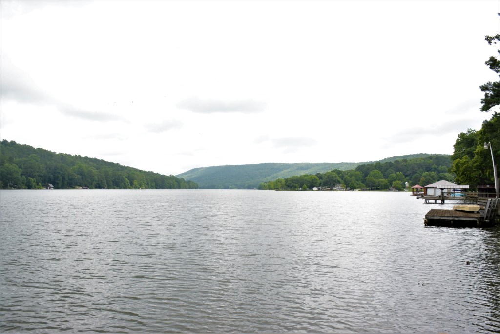
From Vicki Carroll’s dock on Emerald Lake, she has a postcard view: bass swim through the clear waters, herons and ducks nest on the shoreline and the whole lake, including her neighbors’ homes, is ringed by wooded mountains and hills.
A proposed limestone quarry site nearby, however, has Carroll fearing that in a few years, she’ll be looking at a very different scene: dusty air, cloudy waters, sinkholes, vanished wildlife and permanently scarred mountains.
“We must realize that we can’t take back what we destroy,” she said.
Carroll and hundreds of her neighbors in Clay, along with the Sierra Club’s Alabama chapter and local riverkeeper organizations, are opposing this quarry because they believe it will be harmful both for the environment and for nearby homes.
“We certainly understand the demand for and need for products that come from rock quarries, but we think there’s a right place to have these facilities, and we think this is absolutely the wrong place for a quarry,” Cahaba Riverkeeper David Butler said.
PUBLIC OUTCRY
The proposed site for the quarry, which would be operated by Vulcan Materials, is a group of lots on and around Clay-Palmerdale Road: 5886, 5880 and 5890 Clay-Palmerdale Road; 6480, 6638 and 6642 Mountain Heights Road; 7280 Self Road; 7605 Highland Drive; and 7557, 7575, 7641 and 7585 Cedar Mountain Road.
The site includes Butler Mountain, the tallest point in Jefferson County, and neighboring Foster and Praytor Mountains.
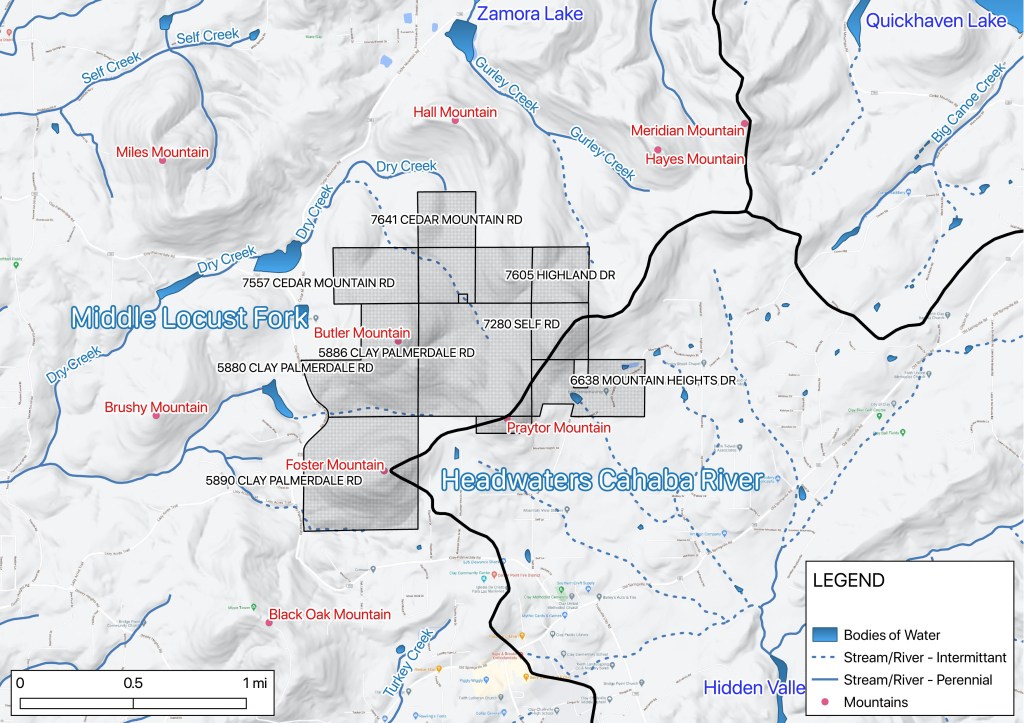
In October 2020, the owner of the properties, Walker Family Holdings Ltd., requested annexation of the properties from Jefferson County into Clay and to rezone them for industrial use. The land’s current zoning in Jefferson County does not permit quarrying use.
Neighbors who showed up to the Oct. 13 City Council meeting were totally surprised by the proposal of a quarry, Carroll said.
Clay Mayor Charles Webster introduced the motion that night, but it died due to lack of action by any council members. The annexation and rezoning were discussed again at a Planning and Zoning meeting a few days later, but the request was withdrawn by Walker Holdings and Vulcan Materials after neighbors voiced concerns again.
Even though the annexation didn’t happen, residents began organizing the Neighborhood Preservation Coalition so they could make a coordinated effort to oppose any future attempts to build the quarry, whether in Clay or in the county under a different zoning category.
“We kind of feel like we’re being held hostage by this issue. We’re losing sleep. Our lives could potentially be turned upside down by this,” said Carroll, who is a member of both the Coalition and the Sierra Club.
There has been no attempt by Walker Family Holdings to re-file for annexation or rezoning since that meeting. In a July email, Webster said he doesn’t “expect to hear any more about this” at Clay City Council meetings.
Vulcan Materials Vice President of Permitting and External Affairs Jimmy Fleming said the company also hasn’t taken any action about the site since October, though they have “reserved our right to go back and look at it.”
“We just honestly haven’t talked about this issue lately,” he said.
If Vulcan Materials does decide to move forward on the site, Fleming said the company would include public meetings as part of its process.
“The feedback we’ve gotten tells me that we’ve got a lot of questions that need to be answered if we decide to file the permits again,” he said. “… We will be very public in the way we go forward with that.”
After their experience during the first annexation request in October, however, Carroll said she and her neighbors are remaining watchful.
“They nearly blindsided us once. We don’t have any confidence that they’re going to be straightforward,” Carroll said. “… We would like our leaders to understand that now is the time to stop it.”
RIGHT NEXT DOOR
The Neighborhood Preservation Coalition has quality of life, property value and safety concerns about the quarry.
Carroll said her neighbors don’t want the noise, airborne dust and additional traffic that would come with blasting and mining activity, particularly since Clay-Palmerdale Road is already a curvy, accident-prone road.
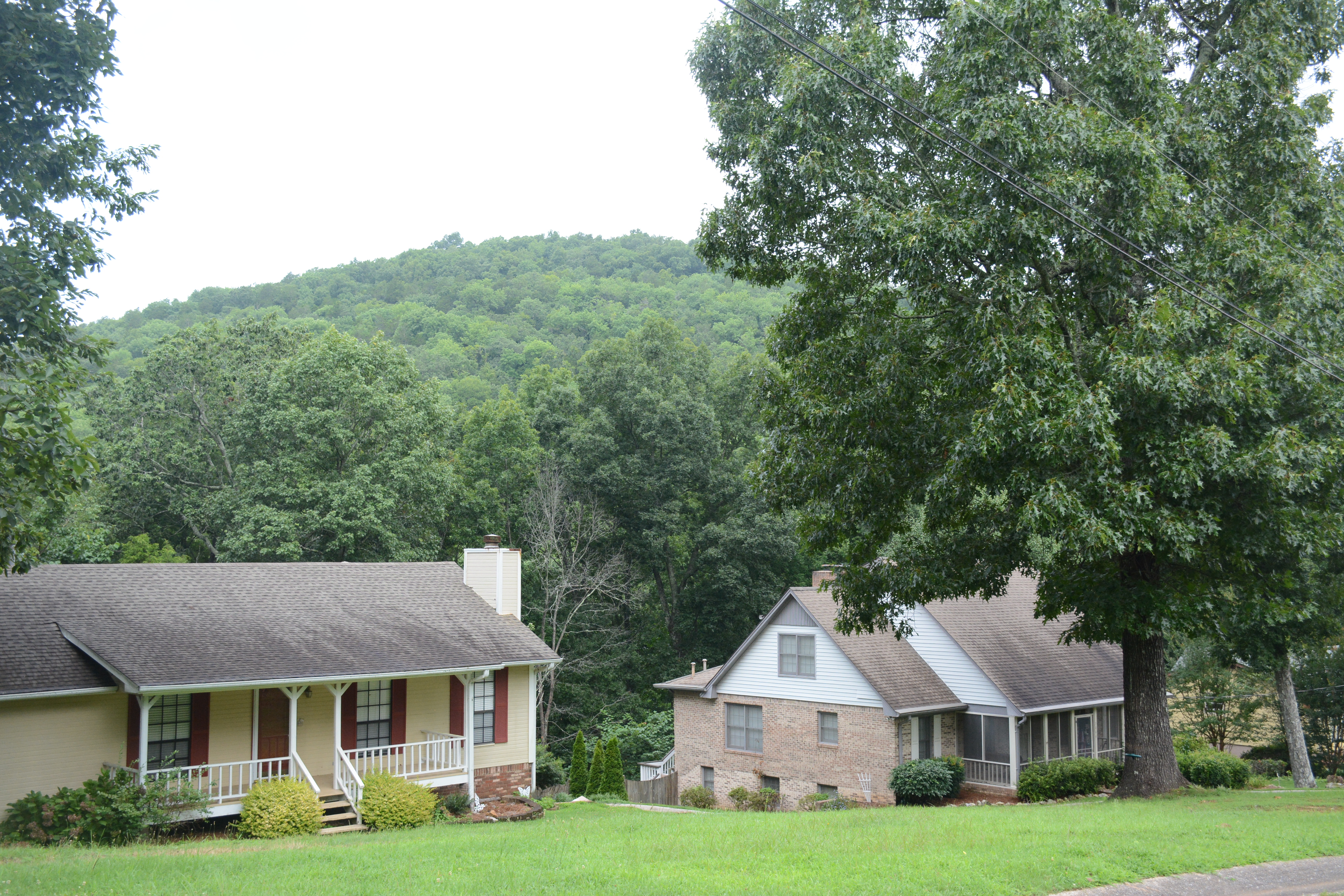
Also, Carroll said, they don’t want to see the natural beauty of the area destroyed. Butler Mountain and its neighboring peaks can be seen from many nearby homes, dominating the landscape.
“I can tell you what a good location for a quarry is not, and it’s not in the middle of a neighborhood,” Carroll said.

Fleming said Clay-Palmerdale Road is a good site “in a number of ways” from Vulcan Materials’ perspective, including the right chemical composition in the rock and access to a good market in need of construction materials for building and road projects.
“You can’t just put a quarry anywhere,” he said.
The site is also near the future route of the Northern Beltline road project, connecting northeast Jefferson County and Bessemer with a six-lane highway around Birmingham.
The large size of the property would actually be an advantage for its neighbors, according to Fleming, because the company would have more room to position the quarry in a way that its activities aren’t visible. He said the quarry pit would not destroy the peaks of Butler, Foster and Praytor mountains.
“It’s not mining the mountain down, it’s basically mining in an area that would be screened by the mountains,” he said. “… The quarry itself would be almost in the valley between some of these mountains.”
While Vulcan Materials may be able to design its site to be minimally intrusive to Clay residents, the ecological sensitivity of Butler Mountain still alarms local riverkeepers and the Sierra Club — especially since they’ve seen quarries destroy Alabama ecosystems before.
WHAT FLOWS DOWNSTREAM
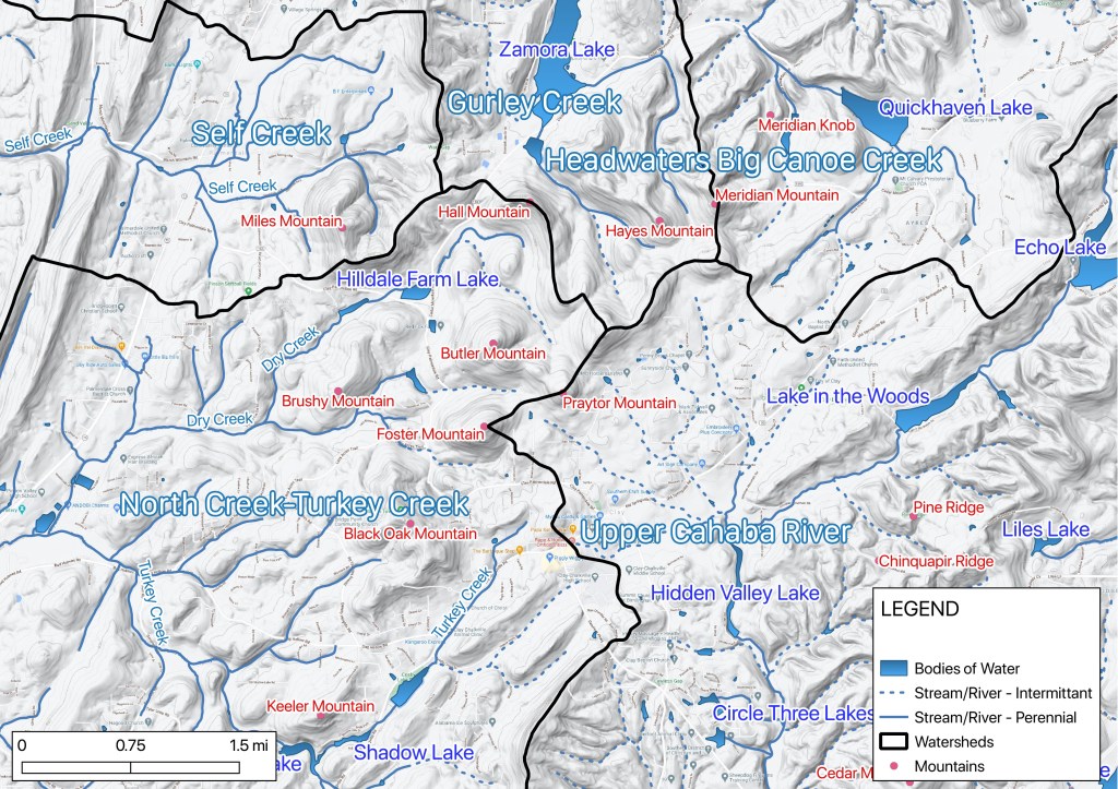
The mountains of Clay are dotted with tiny streams and springs: the headwaters that feed several important creeks and rivers.
Butler Mountain itself is part of the headwaters of Dry Creek, which feeds Turkey Creek. Praytor Mountain is part of the headwater region of the Cahaba River, as well. Within two miles of the proposed quarry property are tributaries to Gurley Creek, Big Canoe Creek and Self Creek, plus small lakes and reservoirs like Hilldale Farm Lake and Emerald Lake.
The quarry property is part of the larger watersheds for the Locust Fork of the Black Warrior River and the Cahaba River, and the Coosa River’s watershed is also nearby.
“These kind of operations have generational impacts,” David Butler said. “… This will be a permanent scar, really, where all three of the Coosa, Black Warrior and Cahaba riversheds touch.”
When it comes to water — whether for wild ecosystems, drinking water or simply recreation — the Butler Mountain area is critical.
“The Upper Cahaba has been so overbuilt that we really need to protect areas just like this … to have any hope of preserving the river,” Butler said.
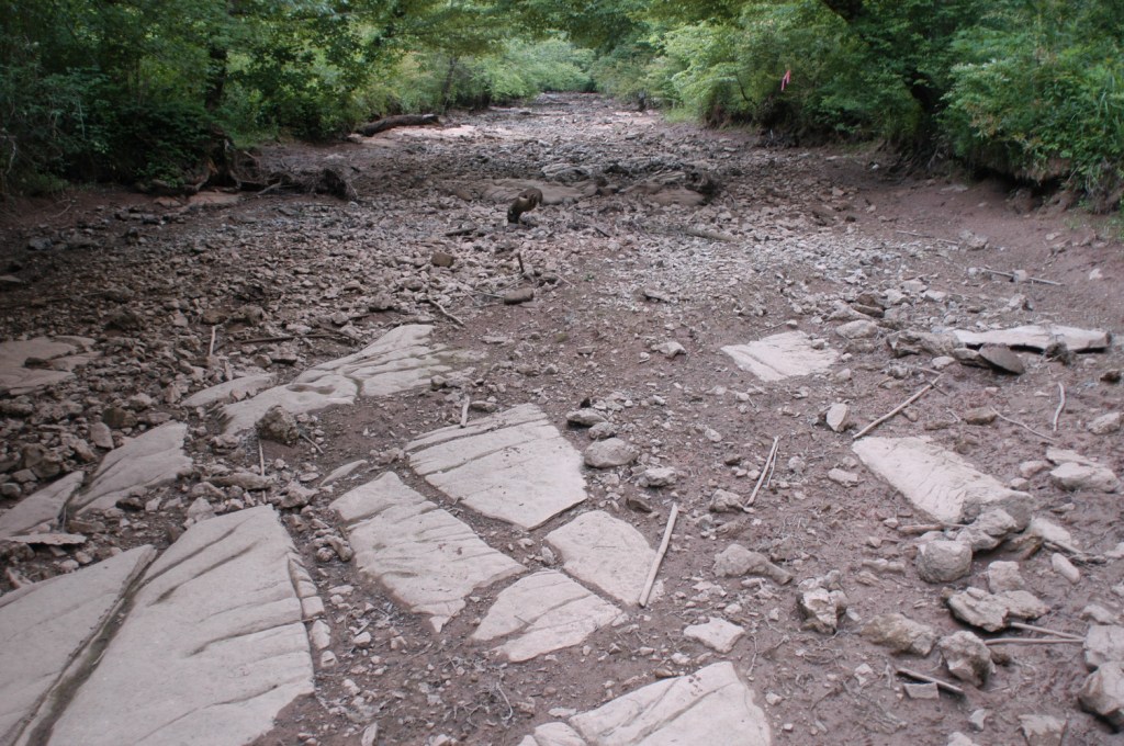
But a quarry could fundamentally alter those tributaries, or even make them disappear.
The quarrying process can pollute groundwater and nearby streams with silt, heavy metals and limestone or other mineral particles, as well as any contaminants like oil or chemicals picked up and carried by runoff from the site. Quarries also spray water to keep down dust and discharge wastewater as part of the mining process.
The effluent from quarry sites can not only worsen water clarity by adding sediment or other particles, but it can also change the temperature, depth, current and pH balance, making streams less habitable for their native species.
“It’s just in such a sensitive, mountaintop headwater region that, in our opinion, it’s just a totally irresponsible location for a quarry, and it should not happen,” Black Warrior Riverkeeper Nelson Brooke said.
Pollution of Buck Creek in 2016 at a Carmeuse Lime and Stone quarry site, in Saginaw, turned the creek nearly white, put the pH balance nearly as high as household bleach and killed off almost all aquatic life. Butler said Carmeuse, which inherited the pollution issue from the site’s previous owner, invested heavily in improving its water treatment and discharge, with visible water quality and wildlife results.
A 2010 study of a stream near a quarry site in Croatia found that species diversity reduced by half, and the overall number of individual organisms was reduced by 85 percent, downstream of the quarry, compared to upstream.
Anne Mathews, an Alabama Water Watch citizen monitor and treasurer of the Friends of Turkey Creek Nature Preserve, said the loss of animal life in these local streams has ripple effects for water quality.
“A creek is not healthy without the animals. Otherwise, we have a drainage ditch,” Mathews said. Turkey Creek Nature Preserve is home to nine threatened or endangered species, six of them aquatic. One of those species, the vermilion darter, can only be found in a couple locations in Turkey Creek and its tributaries.
Turkey Creek is also a popular swimming spot in the Birmingham area, in part because the water is safe to play in, Mathews said.
As part of her work as a citizen monitor, Mathews does regular tests on Turkey Creek to measure its clarity, pH balance, dissolved mineral content and oxygen levels. She also does E. coli testing near swimming holes in the summer.
The creek tends to be more alkaline than most waterways, Mathews said. The addition of limestone to Turkey Creek’s headwaters could raise the alkalinity even higher, while other forms of industrial runoff could lower the alkalinity, instead making it more acidic.
Either way, it would end up tipping Turkey Creek out of its natural balance.
“So if we get more limestone dust and runoff into the creek, it’s going to flow down into Turkey Creek and make it more dangerous for the animals that live there,” she said.
Through the work of the Alabama Water Watch, Mathews said they will have the data to quickly be able to tell if quarry runoff is reaching Turkey Creek in unsafe levels. But it’s easier to prevent a problem than to remove it once it exists, she said.
“Alabama will have invested all this money into Turkey Creek Nature Preserve to have it ruined by Vulcan Materials,” Mathews said.
“This will be a permanent scar, really, where all three of the Coosa, Black Warrior and Cahaba riversheds touch.”
David Butler, Cahaba Riverkeeper
It’s not just about surface water. Quarries also change the water table, the underground level where water saturates the soil and rock.
The interior of Butler Mountain is made up of karst terrain, which Brooke described as a “beautiful maze” of limestone with Swiss cheese–like pockets of sediment, water and underground caves.
As quarries dig downward and reach the water table, they pump water out of the quarrying pits. Brooke said this lowers the water level in the soil and, as the groundwater retreats, it can erode away all the sediment between the limestone formations.
The loss of the water table, and the accompanying sediment erosion, can cause streams to dry up or change course, or it can create unexpected sinkholes.
“That’s a thing that quarries are notorious for, is impacting local groundwater,” Brooke said.
Fleming said any movement to create a quarry on the Clay-Palmerdale Road site would incorporate environmental study and planning to meet Alabama Department of Environmental Management (ADEM) permitting requirements.
That includes a National Pollution Discharge Elimination System (NPDES) permit application, where applicants must list all discharge points and the areas they could impact, as well as estimates of each discharge point’s expected daily flow, temperature, pH balance, oxygen demand and concentration of certain particles and metals. The NPDES permit also requires a pollution abatement and prevention (PAP) plan that identifies day-to-day and emergency control measures for other pollutant sources.
“The state requires that we maintain a site that takes into consideration any types of streams or groundwater or anything else,” Fleming said.
Once a quarry is operation, ADEM requires that it tests the water at effluent discharge points for changes in pH balance and suspended solids twice per month, to ensure they stay within the accepted levels set by ADEM and the federal Clean Water Act. The Supreme Court ruled in April 2020 that Clean Water Act standards apply to groundwater pollution, too.
“We’ve got 350 quarries across the United States. We know how to deal with these issues, and we know how to deal with them in an effective manner so we can comply with the environmental permitting,” Fleming said.
Vulcan Materials operates 502 facilities across 20 states, the District of Columbia, the Bahamas and Mexico, including aggregate (crushed stone, sand and gravel) quarries, ready-mix concrete, asphalt paving materials, clean construction demolition debris and recycled concrete and asphalt paving materials.
A review of the Environmental Protection Agency’s (EPA) Enforcement and Compliance History Online (ECHO) site showed that five of Vulcan Materials’ 29 Alabama facilities had violations in the past three years. Three of the facilities had not met EPA limits on suspended solids, phosphorus levels or pH balance in the sites’ discharge for one quarter during that time period, while the other two facilities’ violations were related to delivering the proper reports.
Sierra Club Alabama State Director Steven DeCaprio believes ADEM and other regulatory agencies are too permissive in their permitting processes and handling infractions.
“If we don’t hear about the plan until it’s submitted to a state agency, then the community is cut out of the process because of … how deferential these regulatory agencies are to polluting corporations, and how unavailable they are for truly impactful community engagement. It’s almost as if the meetings are nearly a formality toward the inevitable passing of giving the corporations what they want,” he said.
He added: “In a state like Alabama, there should be a lot more scrutiny, you know, because once you destroy a river or poison a watershed, there’s no going back.”
For the 2016 contamination of Buck Creek, Carmeuse Lime and Stone was fined only $32,000. Butler said Carmeuse handled the contamination issue well and worked transparently with the Cahaba Riverkeeper, but he believes the state fine and methods for handling infractions is too little.
“The key, to me, in that situation is that if the company hadn’t wanted to do the right thing, the state wouldn’t have made them. And I value what they did to make it right, for sure,” Butler said via email.
DÉJÀ VU
In the Butler Mountain site, Brooke sees the potential for a replay of what happened at another Vulcan Materials site nearly 20 years ago.
At the Bessemer quarry site on Powder Plant Road, Brooke said the Black Warrior Riverkeeper found signs in the early 2000s that Vulcan Materials was not doing enough to control pollution being discharged from the property.
After the Riverkeeper’s report, an ADEM inspection in May 2002 agreed, finding that Fivemile Creek had a noticeable decrease in clarity downstream from the quarry’s discharge, and that the company was not doing enough to meet the standards of its PAP plan.
After attempts by Vulcan Materials to fix the problems, an August 2004 inspection still found that the pH level and pollutants entering the creek did not meet state standards.
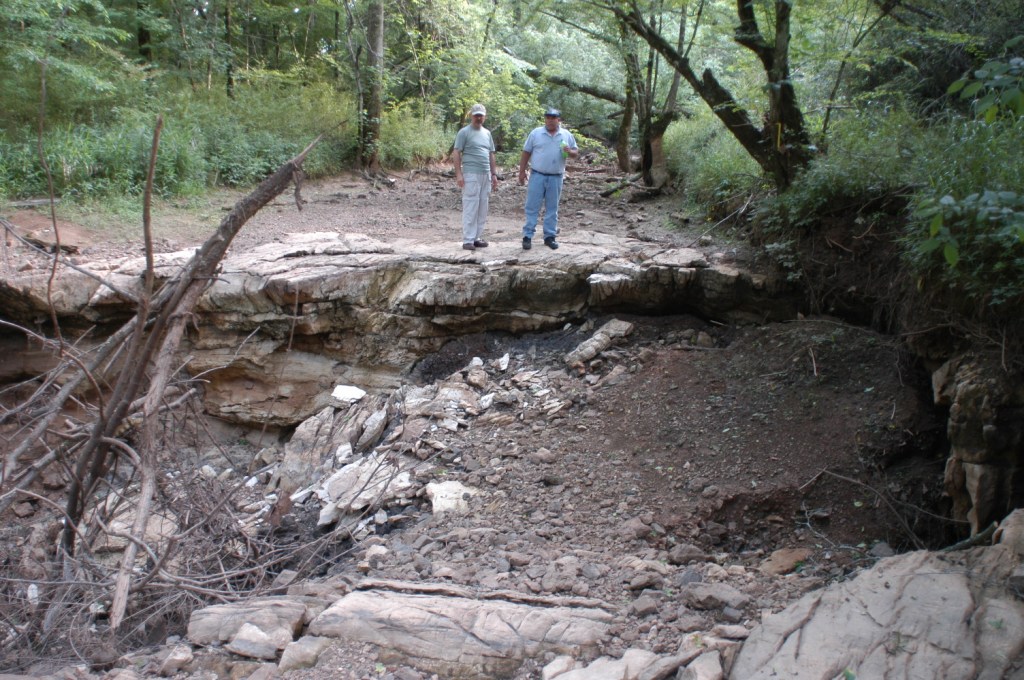
The site, like the Clay-Palmerdale Road property, had karst geology under the surface, and the groundwater being pumped out led to sinkholes forming and Fivemile Creek running dry for miles.
“Once that whole gaping area has formed, only time and sedimentation can fill the wounds,” Brooke said.
Black Warrior Riverkeeper notified Vulcan of its intent to sue over an alleged 465 violations of the Clean Water Act between 2000 and 2004.
ADEM and Vulcan Materials agreed to a consent order in November 2004, assessing a fine of $50,000 for 24 discharge violations and five reporting violations. Vulcan also agreed to remediate the issues that had caused the violations and to short-term increases in the frequency of monitoring and reporting.
Black Warrior Riverkeeper also attempted to appeal the penalty that ADEM and Vulcan negotiated, but this appeal was dismissed.
The Bessemer quarry was found to be in compliance with ADEM regulations in March 2005. During a flyover in November 2005, Brooke took pictures of discoloration still visible in the creek and water sources within the quarry site. ADEM’s followup inspection in response to his complaint, however, found that Vulcan was not exceeding any of the state’s discharge limits.
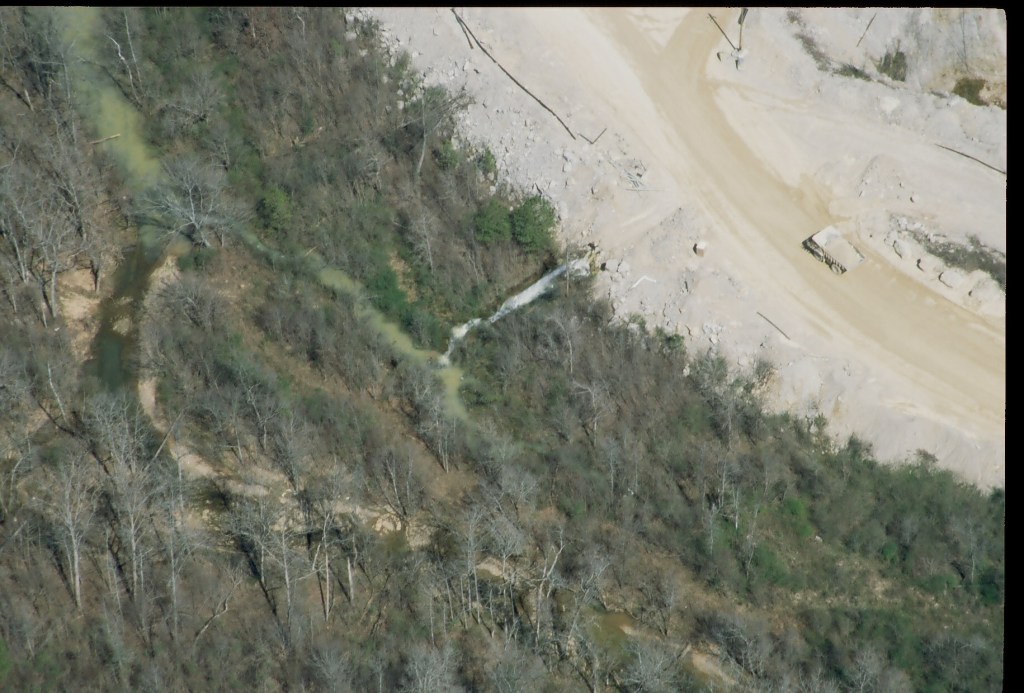
Even years later, Brooke said the creek still has troubling flowing in its regular path during dry seasons, and it is still affected by the sinkholes.
“It’ll never be what it was,” he said.
Vulcan Materials closed the quarry pit and opened a second one on the Bessemer property in 2005. However, Fleming said this was because the minable material of the first quarry pit had been “exhausted,” unrelated to any of the environmental concerns happening at that same time.
If the water table and geology at the second Bessemer quarry pit isn’t protected, Brooke said, the same problems could occur again in the future.
“These are not isolated incidents,” Brooke said.
He said this environmental damage is “necessary fallout” of mining in a sensitive location. A 2001 U.S. Geological Survey review of mining in karst geology found all of the effects that the riverkeepers are concerned about — water contamination, groundwater loss, habitat destruction, dried up streams and sinkhole collapse — have been common at karst mining sites across the country for decades.
“It’ll never be what it was.”
Nelson Brooke, Black Warrior Riverkeeper
Birmingham-Southern College environmental sciences student Brianne Kendall reviewed the potential environmental impacts of the Butler Mountain quarry site on Turkey Creek. As part of her paper, she looked at the Bessemer Quarry and three other quarry sites: Martin Marietta Auburn Quarry; Berry College Quarry in Rome, Georgia; and Berkeley Pit in Butte, Montana.
Martin Marietta has operated its quarry in Auburn, near Chewacla State Park, for 50 years. In the early 2000s, sinkholes that formed near the quarry site disrupted the flow of surface water, drying up a section of Chewacla Creek and causing habitat loss for the creek’s mussel species.
Brooke said in an email about Alabama quarry sites that this is an ongoing problem for residents near Chewacla Creek, who are still trying to address the environmental impacts.
The Florida Rock quarry, near Berry College’s Victory Lake, was another quarry set on karst geology. It operated for over 30 years, pumping millions of gallons of water out of the quarry site every day.
The pumping caused such a severe loss in water table levels that in June 1986, four sinkholes opened overnight and completely drained the manmade lake. Today, the area is mostly wetlands.
At the Berkeley Pit, 30 years of mining caused area streams and wetlands to dry up. Eventually, groundwater contaminated with copper ore began to fill the quarry pit, which had to be closed in 1982. The groundwater is still as acidic as gastric acid and cannot be effectively cleaned. The pit has to be specially managed as an EPA Superfund hazardous waste site to avoid contaminating nearby water systems.
If a quarry begins operations at Butler Mountain, some of its effects will be seen nearly immediately. But others, like what happened at the quarries in Auburn, Berry and Butte, could take decades of buildup and cause decades of damage, some of which may not be fixable.
Both the long-term and the short-term consequences are what keep Carroll up at night.
“For most of us who are adults, it will change for the remainder of our lives,” she said.
Main article image by Sydney Cromwell.

3 thoughts on “‘Absolutely the wrong place’”