
VORTEX-SE program setting new goals for tornado safety, forecasting
by Sydney Cromwell
It’s 2:30 a.m., and a tornado is about to touch down near your home.
Do you have a safe place to go? Is there enough time to get there? Most importantly — are you even aware that the tornado is coming?
While the Plains states are called “Tornado Alley,” the tornadoes that occur in the Southeast tend to cause far more damage, injuries and deaths. The VORTEX-SE project started in 2015 to study why Southeastern tornadoes are so dangerous and to find new ways to get better and faster information out to the public.
Since completing its most recent round of field work this spring, VORTEX-SE is now getting started on the next phase of translating that data into real-world results
THE DANGER ZONE
The Southeast has several factors that make its tornadoes more dangerous than in the rest of the country.
For starters, places like the Midwest and the Plains tend to have defined tornado “seasons,” but weather conditions in the Southeast can produce tornado conditions nearly year-round, with a peak in spring and frequently a second peak around November.
“It’s pretty much a 12-month deal in the Southeast, and that makes it unique,” said Alan Gerard, the VORTEX-SE federal programs coordinator at the National Severe Storms Laboratory (NSSL). He spent nearly 20 years in the National Weather Service (NWS) office in Jackson, Mississippi, before joining the NSSL.
Nighttime tornadoes are also more common here, rather than in the afternoons or evenings, Gerard said, meaning that fewer people are awake to respond to weather threats that pop up.
Much of the research on tornadoes has historically happened in “Tornado Alley,” where wide, flat plains dominate the landscape. But the Southeast’s forests and hills not only interrupt weather radar signals, but they also change tornado behavior.
If people in the Southeast are expecting tornadoes to act like they do on the Great Plains, research has shown they may not realize when they’re at risk.
“The issue here is that the plains are flat, the plains are open, especially in these areas where most of these observations are gathered,” said Tony Lyza, a weather scientist who has worked with VORTEX-SE and other storm research programs through NOAA. “… We don’t know how this changes if you have a forest of southern yellow pine, or if you have a bunch of hills or buildings. We really don’t know how that varies.”
SAND MOUNTAIN: A CASE STUDY IN SOUTHERN STORMS
The Sand Mountain area of northeastern Alabama is an example of how geography affects tornadoes and severe storms.
Lyza did his doctoral research on tornado formation in this region. Before he came to University of Alabama – Huntsville, Lyza said he had heard that storms seemed to intensify and rapidly form tornadoes in Sand Mountain.
He studied 25 years of NWS data and found that the area was indeed significantly more prone to tornadoes and strong storms. So, Lyza took equipment out to the area to study the atmospheric and weather conditions and “try to figure out exactly what might be going on, what might be leading to this maximum in tornado formation on Sand Mountain.”
He found that, while Sand Mountain is “not a huge mountain or huge obstruction height-wise,” the shape of the plateau was disrupting storm cells and creating a “standing wave” of air that made the atmosphere less stable and increased wind speed and shear — both major factors in tornado formation — as storms passed across the plateau.
The amount of damage a tornado produces depends not only on the behavior of storms, but also on the behavior of people.
For a long time, researchers questioned whether people in the Southeast were simply too complacent about severe storms and weren’t paying attention, Gerard said.
“A lot of the research that we’ve done in the last number of years, particularly with VORTEX-SE, is [showing] that’s definitely not the case, that people are definitely paying attention, but there are a number of societal difficulties and factors,” he said.
Those elements include living in rural locations, where it can be difficult to get timely storm warnings, or living in buildings like mobile and manufactured homes, which are more vulnerable to storm damage and don’t have a safe place for residents to hide.
If a family needs to leave their home and travel to another building to safely shelter from a tornado, they are at more risk and need more time to respond. Given how quickly tornadoes form, Gerard said, current meteorology often isn’t able to give them an early enough warning.
“You can’t get a tornado warning and do that in five minutes. You need time,” he said.
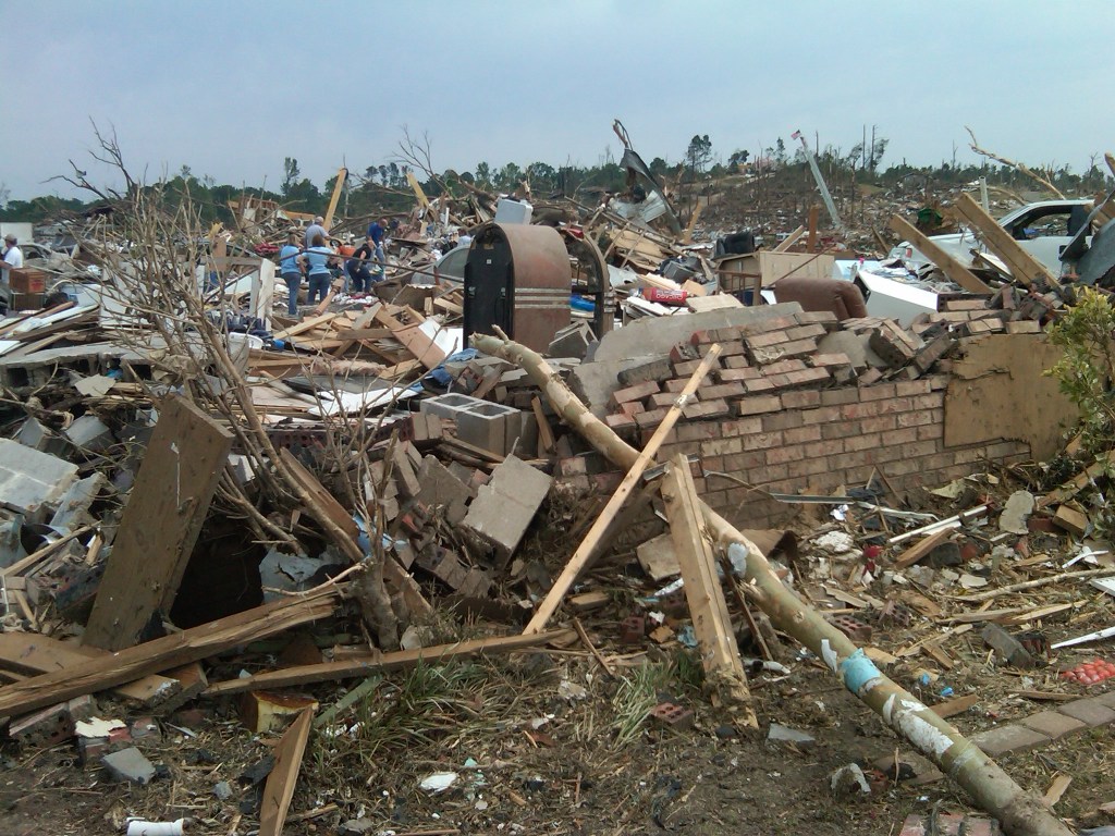
Because of all these factors, most people in Alabama have a tornado disaster burned into their memories: the March 2019 storm that killed 23 people in Lee County; the April 2011 outbreak, when 238 people died in Alabama alone, part of a larger storm event that saw more than 360 tornadoes touch down across 21 states; the 2008 Super Tuesday tornado outbreak, which killed 57 people, four of them in Alabama; the Oak Grove tornado of 1998, which killed 32 people as it traced a 30-mile path west of Birmingham; or the 1974 “Super Outbreak” that hit northern Alabama and 12 other states, causing 86 deaths.
Just this year, nine people have died during tornadoes in Alabama. One of those deaths was caused by the same storm system that killed 25 people in Rolling Fork, Mississippi, in March.
ARMED WITH INFORMATION
Since VORTEX-SE began in 2015, the goal has been “arming people with the information they need to become more resilient,” Lyza said. It is focused not only on improving weather science and answering some of those unknowns about tornadoes, but also using social science to learn what information people need and the best way to get it to them.
For example, part of the VORTEX-SE program is a partnership with the Mississippi-Alabama Sea Grant Consortium (MASGC) to run a pilot program on storm preparedness education at two mobile home parks in Mississippi.
While Tracie Sempier, the resilience engagement lead for MASGC, is sharing data from VORTEX-SE research in her presentations to residents, she said she is also reporting back to the program about how people respond to the information and what questions they still have. These details can help refine the way that weather scientists look at their data and share it with the public.
“I really appreciate having such easy access to the scientists that are on the ground,” Sempier said. “… People appreciate that and they trust that. It makes the relationship stronger.”
Gerard said one of the first goals of VORTEX-SE was figuring out better, safer ways to get scientists on the ground to monitor storm systems and potential tornadoes in the Southeast. That led to the 2022-2023 PERiLS (Propagation, Evolution, and Rotation in Linear Storms) program that enabled researchers to “do some impactful field work, where we were able to observe at close range a number of severe weather events,” Gerard said.
The PERiLS team used mobile weather stations and Doppler radars, lightning sensors and other instruments attached to vehicles, as well as aircraft and weather balloons, to find storms likely to produce tornadoes and then get close enough to observe and collect data.
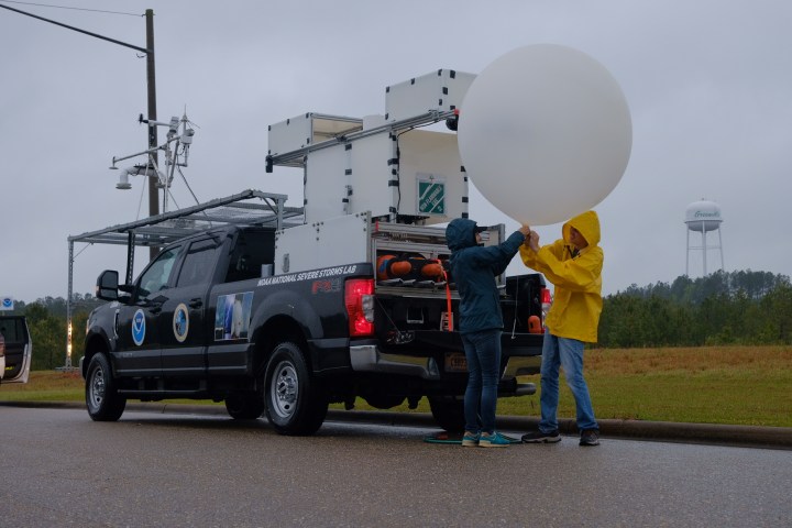
Lyza, who served as physical science coordinator for PERiLS, said the field team deployed four times in March and April 2022, observing a total of 16 tornadoes in a region extending from southern Missouri down to Louisiana and east to Alabama.
This spring, he said, the team had a couple of “busts,” where the storms didn’t produce any tornadoes, but they also were in the field for the Rolling Fork tornado and for an outbreak that happened in northern Alabama and southern Tennessee at the end of March.
“Rolling Fork is a huge case for us,” Lyza said.
Catching an EF-4 tornado on the ground was a big opportunity for their research, Lyza said, but also risky. After realizing they wouldn’t be able to beat the storm, he said, the team decided to do its sampling and measuring work in the rainy portion north of the tornado and “not go in the path of that thing.”
Even just catching a glimpse of the tornado and seeing the damage in Rolling Fork the next day was “really horrific,” he said.
As part of its research, PERiLS also sent out teams to do damage surveys and get the scope of the human impact after the storms had passed.
The data and “incredible observations” the PERiLS scientists collected will be valuable for the VORTEX program in the coming years, Lyza said. But the field teams were also able to make a more immediate impact, according to Gerard, by feeding real-time information to local NWS offices and meteorologists to help them track the storms as they happened.
SPREADING THE SAFETY MESSAGE
When it comes to storms, Sempier said it’s surprising how many people know the “right” thing to do, but haven’t thought about whether that “right” answer is actually useful.
In talking to residents of the mobile home parks that are part of the MASGC pilot education program, Sempier said she often asks them about the safest place to be during a tornado. They tell her it’s the basement, which is “right” — but if you live in a mobile home without a basement, that answer isn’t really helpful.
That’s why the conversations started by the pilot program are so critical, Sempier said.
“I’d like to think that those people that I was able to talk to have better storm awareness,” she said.
In 2020, the NSSL decided it wanted “to be a little bit more present within the communities,” Sempier said, and make sure that research from programs like VORTEX-SE was getting delivered to vulnerable groups in the Southeast.
To start out, the MASGC selected two mobile home parks in Biloxi. Sempier said they were chosen because they had multiple “stressors” — not just the vulnerability of the mobile homes to tornado damage, but also flooding risks, elderly or disabled residents who couldn’t easily evacuate and language barriers that hindered communication of safety information.
“A lot of the Vietnamese population was not receiving severe storm warnings in Vietnamese. Everything was in English,” she said. The same problem exists for the Hispanic and Cambodian populations in the area.
“I think there was more of a need than what we even had thought when we first started.”
Tracie Sempier, Mississippi Alabama Sea Grant Consortium
When the MASGC team went door to door to talk to residents about storm preparedness, “many of them said, ‘Well, I know I’m not safe in this mobile home,’” Sempier said, but they didn’t necessarily know a safe place to go, or how to get there.
Beyond knowing that a basement is the “right” place to be, Sempier said many people just haven’t thought through what they would do in different scenarios, such as a tornado striking while they’re at work or their kids are at school.
“I think there was more of a need than what we even had thought when we first started,” she said.
The MASGC team hosted an expo for the two communities, but it was about more than just tornadoes, Sempier said. They brought in experts to talk about fortifying homes, floodplains and flood insurance, Red Cross emergency supply distribution and even mental health resources.
“We have so many compounding disasters on the coast, and we want people to know that we have resources that can help them cope,” Sempier said.
For instance, during the damage survey after the Rolling Fork tornado, Sempier said, she met a man with a glove covering his injured hand. He didn’t have insurance and was afraid to seek medical care, she said. Finding a way for him to access free or low-cost health care is another much-needed resource for the area.
The Biloxi Public Library shared historical photos of previous storm damage during the expo, which Sempier said was “really powerful” in helping people to grasp the potential hazards.
There are many ways to make people less vulnerable to tornadoes, she said, whether it’s getting weather alerts on their phone or teaching them CPR or how to use a chainsaw to remove debris.
“We want people to have a better self-efficacy, so they can help themselves,” she said.
When she does storm safety training, Sempier said having access to VORTEX-SE data lets her give more comprehensive answers to residents’ questions.
“I don’t know that I would have been able to achieve some of that interest, if I hadn’t had such an easy and collaborative connection with the people that are doing that research,” she said.
Sempier said the pilot program has also led to valuable connections with existing groups that already serve vulnerable populations in the Southeast and can spread their storm safety message farther than MASGC can on its own.
She has been traveling to rural libraries and training staff members to act as “ambassadors” to educate others. Sempier said she is also working with cooperative extension programs, including one in Auburn, on ways to share storm safety curriculum.
“The pilot work, I think, is starting to lay a foundation for what we’re going to be able to do,” Sempier said.
NEXT STEPS
There are still a lot of limitations and unknowns around tornadoes, and that’s where VORTEX-SE wants to focus next, Gerard said.
For example, more accurate predictions 30 to 90 minutes ahead of a storm, he said, could potentially save lives by giving people the time they need to get to safety. But first, weather science has to improve enough to make that possible.
That timeframe, between when tornado watches and warnings are typically issued, will be a focus for VORTEX-SE in the next year or two, Gerard said.
“That period of time between the watch and the warning is a really critical time for people making protective decisions,” he said.
Researchers will use the data gathered by PERiLS and other VORTEX-SE studies from the past three years to see if they can find new markers that predict tornado formation with more speed and accuracy. Gerard said they are also working on a new computer modeling system.
“That system is showing a lot of promise, but I feel like we have a lot of work to do to improve the data that’s going into that model, to really make it a system where people can really rely on [it],” he said.

Gerard said VORTEX-SE leaders are also considering a semi-permanent version of PERiLS, which would deploy field equipment in a single location to collect data for a couple years.
Understanding whether a tornado changes after it hits a building is another “extraordinarily complicated” question both for weather scientists and engineers, Lyza said, but “it’s probably one of the questions that can do the most good for the public for us to understand, to become more resilient to tornadoes.”
In the next few years, Gerard said there will be a “focused effort” to take all the data that VORTEX-SE has gathered and “get it into the hands of practitioners,” such as TV meteorologists, local emergency management agencies and community leaders.
THE CLIMATE QUESTION
We don’t know yet how climate change will affect tornado formation and strength, or even if the location of “Tornado Alley” or the time of year when tornado season peaks could change in the future. While there’s a clear link between warming oceans and intense hurricanes, the picture for tornadoes is more mixed.
Warming air temperatures create more instability in the atmosphere, which is favorable for severe storms and tornadoes; at the same time, those temperatures also decrease wind shear, which makes it harder for tornadoes to form.
Weather scientists will continue to have to grapple with these factors, and it may change the future of tornado prediction in unexpected ways.
Main article image of a PERiLS field vehicle during a storm. Photo by Jacob Carlin, courtesy of VORTEX-SE.

One thought on “The calm before the storm”